
Garmin Maps for Every Activity
ActiveGPS stocks the full range of genuine Garmin maps for sat nav, handheld GPS and marine devices. All maps are supplied on SD or microSD card unless otherwise stated, and are purchased directly from assigned Garmin UK distributors. We are official authorised Garmin Internet Retailers, so you can be confident you are buying authentic products with full Garmin support. Prefer to browse by device type rather than map series? See our Sat Nav and GPS Maps page to find maps for your specific car, motorcycle, truck, motorhome or handheld GPS device. Call us on 01733 777623 Monday to Friday, 9:30am to 5:00pm if you need help choosing the right map for your device.
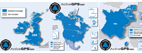
Garmin City Navigator NT
Road maps with street-level detail for Garmin Drive, nuvi, zumo, Oregon and Montana devices. Ideal for in-vehicle and on-road cycling navigation.
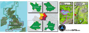
Garmin TOPO Maps
Topographical maps with contours and elevation data for hiking, trekking and outdoor use. Compatible with Garmin eTrex, GPSMAP, Montana and Oregon devices.
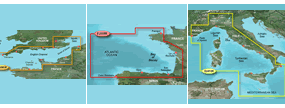
Garmin BlueChart g3
Marine charts for UK and European waters, compatible with Garmin chartplotters and marine handheld GPS devices. One-off purchase supplied on SD/microSD card.
Garmin Navionics+
Subscription-based marine charts with daily updates via the ActiveCaptain app. Compatible with Garmin chartplotters. Available in Regular and Large coverage sizes.
Prefer to browse by device type? Visit our Sat Nav and GPS Maps page to find maps for your specific car, motorcycle, truck, motorhome or handheld GPS device.
Garmin Maps Buying Guide
Compare Garmin Map Series at a Glance
| Map Series | Best For | Contours / Elevation | Waterways / Terrain | Compatible Devices | Format | Notes |
|---|---|---|---|---|---|---|
| Garmin City Navigator NT | Road navigation, driving | No | No | Drive, nuvi, zumo, Oregon, Montana | SD/microSD card | Street-level detail, points of interest, speed limits and lane guidance |
| Garmin TOPO Maps | Hiking, trekking, outdoor | Yes | Trails, footpaths | eTrex, GPSMAP, Montana, Oregon | SD/microSD card | Contours and elevation data for hiking, trekking, orienteering and geocaching |
| Garmin BlueChart g3 | Marine, coastal/inshore | Depth contours only | Coastal/inland waters | Chartplotters, marine handhelds | SD/microSD card (special order) | One-off purchase, special order, non-returnable |
| Garmin Navionics+ | Marine, subscription-based | Depth contours | Coastal/inland waters | Compatible chartplotters only | Subscription, ActiveCaptain app | Daily chart updates; Navionics Vision+ tier adds satellite imagery and 3D views |
| Garmin GB Discoverer | Outdoor, Ordnance Survey mapping | Yes | Paths, routable roads | GPSMAP, Montana, Oregon, Edge | SD/microSD card | Discontinued by Garmin, limited stock remaining |
Garmin City Navigator NT
Garmin City Navigator NT maps provide detailed road maps down to street level, covering roads, points of interest, speed limits and lane guidance for your chosen coverage area. Titles are available for Europe, North America and other regions, and are supplied on SD or microSD card. City Navigator NT is compatible with a wide range of Garmin devices including Drive, nuvi, zumo, Oregon and Montana. Avtex Tourer sat navs also use City Navigator NT maps. View Garmin City Navigator NT maps.
Garmin TOPO Maps
Garmin TOPO maps provide topographical mapping including contours, elevation data, trails and footpaths, making them ideal for hiking, trekking, orienteering and geocaching. Titles are available for Great Britain and a number of European countries. Compatible with Garmin eTrex, GPSMAP, Montana and Oregon devices. View Garmin TOPO maps.
Garmin BlueChart g3
Garmin BlueChart g3 charts provide detailed marine charts for coastal and inshore waters, with 30cm depth contours, Auto Guidance route planning (g3 Vision only), depth range shading and Navionics inland waters coverage. Compatible with Garmin chartplotters and a range of marine handheld GPS devices. BlueChart g3 titles are special order items made to order after purchase and cannot be cancelled or returned. View Garmin BlueChart g3 charts.
Garmin Navionics+
Garmin Navionics+ is a subscription-based marine chart with daily updates delivered via the ActiveCaptain app, including depth contours for coastal and inland waters. Navionics Vision+ is the premium tier, adding satellite imagery, aerial photography of ports and marinas, and 3D chart views. Both are available in Regular and Large coverage sizes and are compatible with Garmin chartplotters only. View Garmin Navionics+ charts.
Garmin GB Discoverer
Garmin GB Discoverer maps provide Ordnance Survey mapping in digital form, including terrain contours and elevation data, for use with compatible Garmin devices including GPSMAP, Montana, Oregon and Edge. The GB Discoverer range was discontinued by Garmin but we hold limited remaining stock. View remaining Garmin GB Discoverer stock.
Which Map is Right for My Device?
If you are unsure which Garmin map is compatible with your device, check the individual product page for the compatibility list, or call us on 01733 777623 Monday to Friday, 9:30am to 5:00pm. You can also contact us online with your device model number and we will advise on the correct map title.
Frequently Asked Questions
Are Garmin maps supplied on SD card?
Yes. The majority of Garmin maps stocked by ActiveGPS are supplied on preprogrammed SD or microSD card, ready to plug into your compatible Garmin device. BlueChart g3 marine charts are special order items made to order after purchase.
Can I use a Garmin map on more than one device?
Garmin maps are locked to the device or memory card they are installed on and cannot be transferred or shared between devices. Each map purchase is for use with a single device.
Do I need to update my device software before installing a new map?
Yes, Garmin recommend ensuring your device has the latest software before installing a new map card. Software updates are available free of charge via Garmin Express.
What is the difference between Garmin BlueChart g3 and Garmin Navionics+?
Garmin BlueChart g3 is a one-off purchase marine chart compatible with Garmin chartplotters and some marine handheld GPS devices. Garmin Navionics+ is a subscription-based chart with daily updates via the ActiveCaptain app, compatible with Garmin chartplotters only. Both are genuine Garmin products available from ActiveGPS.
 Why Buy from ActiveGPS?
We are official authorised Garmin Internet Retailers, offering genuine Garmin products, accessories, and maps. All our stock is purchased directly from assigned Garmin UK distributors - we do not source from the grey market and never sell counterfeit products.
When you buy from ActiveGPS.co.uk, you can be confident that you will receive full Garmin support and the peace of mind that comes with purchasing authentic, genuine products.
This page was last updated on: 9th August 2026