FREE UK delivery when you spend £50 - see more delivery options.

Homepage / GPS / Marine / Chartplotters / Garmin GPSMAP 1022, GPSMAP 1022xsv
Product Codes: GAR1022, GAR1022X
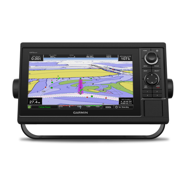
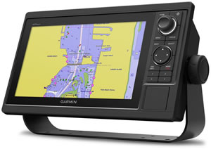
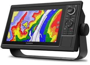
Garmin GPSMAP 1022 chartplotters features a 10-inch colour windscreen display and comes preloaded with worldwide basemap. There is an SD card slot to add additional Garmin BlueChart g3 marine charts to the Garmin GPSMAP 1022 chartplotter.
The Garmin GPSMAP 1022 comprises of two models;
1. Garmin GPSMAP 1022 (no sounder/sonar capability)
2. Garmin GPSMAP 1022xsv
The Garmin GPSMAP 1022 features a high-sensitivity internal 10Hx GPS/GLONASS that will update your position and heading 10 times per second. Using WiFi you can also connect with a smartphone or tablet.
![]()
Garmin GPSMAP 1022 with Worldwide Basemap - £1379.99
![]()
Garmin GPSMAP 1022xsv with Worldwide Basemap - £1579.99
 Deliveries
We offer UK, Europe and Worldwide deliveries. We despatch orders at 4:30pm on Monday, Tuesday, Wednesday, Thursday and Friday. We need to receive your order on those days by 3:00pm. When possible we may despatch orders received after that time. No orders are despatched on Saturday, Sunday or Bank Holidays in England and Wales.
We offer FREE UK delivery* on all orders of £50.00 or more, plus next working day and guaranteed Saturday delivery options. Click here for further info. All options also appear at the basket pages. *Excludes Northern Ireland for chartplotters, fishfinders, etc. Please contact us for courier cost to dispatch to Northern Ireland prior to placing your order.
DELIVERY: Please note: These items weigh in excess of 2Kg and may attract a higher delivery charge. Royal Mail 1pm, 9am, Saturday delivery and International Signed For may not be available with this product. At our option we may use a courier and delivery could take two days or more. If you require urgent delivery please e-mail before placing your order.
The Garmin GPSMAP 1022 comprises of two models;
‣1. Garmin GPSMAP 1022 with Worldwide Basemap
‣2. Garmin GPSMAP 1022xsv with Worldwide Basemap (xsv with ability to add a Garmin transducer)
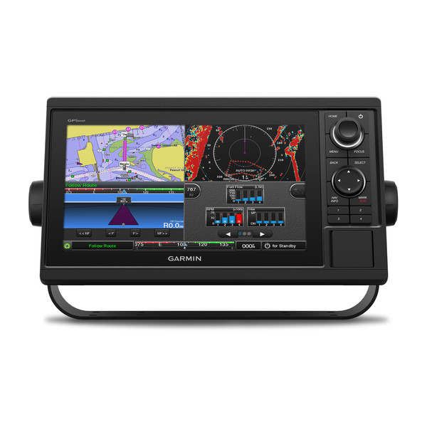
The Garmin GPSMAP 1022 chartplotter features a 10-inch colour screen, keypad interface and multifunction control knob. There are also user-programmable keys to make controlling the chartplotter easier. You can save 5,000 accurate way points and navigate back to them quickly and easily. Waypoints, tracks and frequently used routes can be transferred too and the Garmin chartplotter allows the transfer of industry-standard GPX software formatted data files. With both Garmin GPSMAP 1022 marine chartplotters you can also add Garmin BlueChart g3 or BlueChart g3 Vision marine charts for navigation on the water all over the world. The Garmin GPSMAP 1022 is ideal for cruisers, sailors, sailing racers, recreational boaters and more.
Built-in WiFi connectivity enables control of the Garmin chartplotter using BlueChart Mobile 2.0 app or Garmin Helm app whereby you can view and operate the chartplotter with a compatible smartphone or tablet. This increases the situational awareness for the mariner. Plan routes on you iPad or iPhone and wirelessly transfer them to your boat's compatible networked Garmin chartplotter. You can also stream and control the VIRB action camera from the chartplotter.
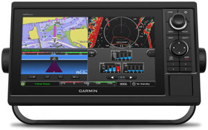
You can share sonar, maps, user data, dome or open-array radar, IP cameras and Panoptix sonar.
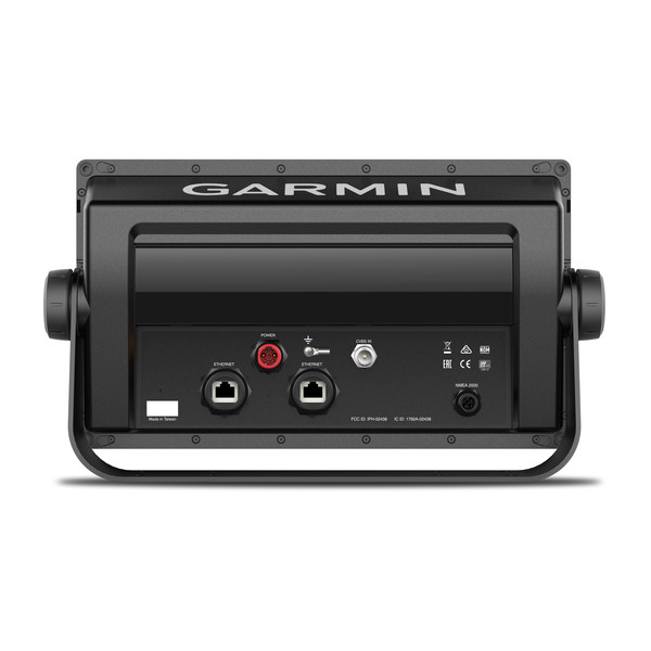
Heading and position is refreshed on screen 10 times per second enabling fluid viewing of your boat or yacht GPS position. There is a high-sensitivity, fast, responsive 10Hz GPS and GLONASS receiver. The GPSMAP 1022 chartplotter also features NMEA 2000 and NMEA 0183 connectivity.
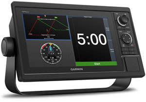
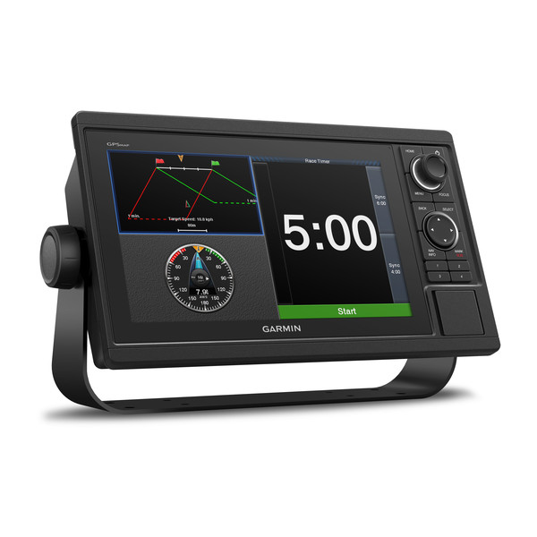
SailAssist features provides you with wind-maximising competitve edge with pre-race guidance such as virtual starting line. It will tell you time to burn before the start, laylines, race timer (syncronised across all your networked Garmin GPS devices), enhanced wind rose, heading and course-over-ground lines, set and drift and true and apparent wind data.
Built-in ANT connectivity enables connection to the Garmin quatix marine watch, Nautix in-view display, gWind Wireless 2 transducer, GNX Wind marin instrument and wireless remote controls.
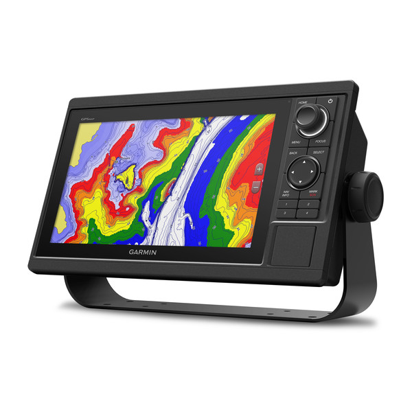
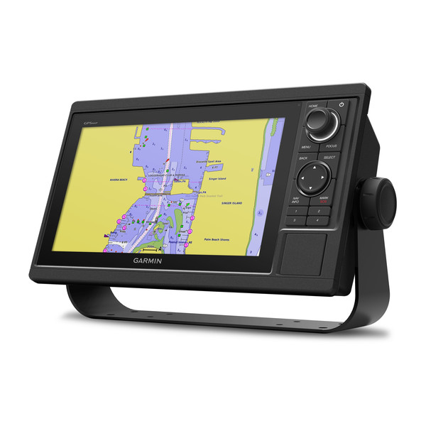
The Garmin GPSMAP 1022 is preloaded with a worldwide basemap. Additional detailed Garmin Bluechart g3 marine charts on pre-programmed microSD/SD card can also be purhcased from ActiveGPS. The very best and latest charts, named BlueChart g3 Vision include premium features such as high resolution satellite imagery of harbours, ports, etc, auto guidance, MarinerEye - keep an eye on 3D information above the waterline and FishEye - provides 3D information below the waterline.
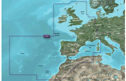
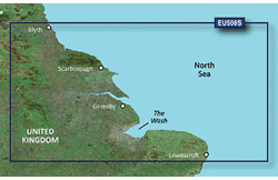
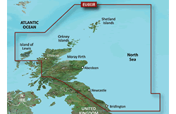
Garmin BlueChart g3 Vision UK and European titles come in three different sizes or areas of water - Garmin BlueChart g3 Vision Small, Garmin BlueChart g3 Vision Regular and Garmin BlueChart g3 Vision Large. Available Garmin BlueChart g3 Vision titles for UK waters include: Thames Estuary (Small Chart), English Channel (Regular Chart), Scotland, West Coast (Regular Chart) and Europe Atlantic Coast (Large Chart). Find your perfect UK and European BlueChart title. Heading to North America? We also sell US and Canadian g3 BlueCharts.
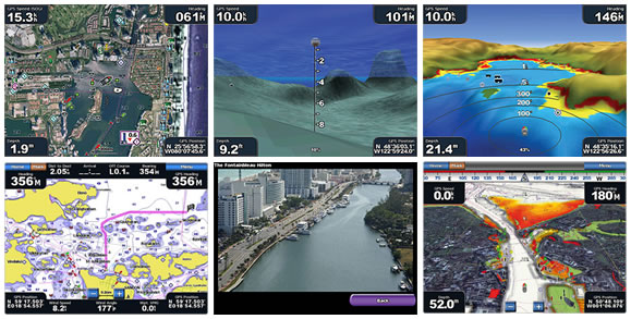
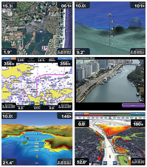
Pictured below: screenshots from the Garmin BlueChart g3 Vision chart series.
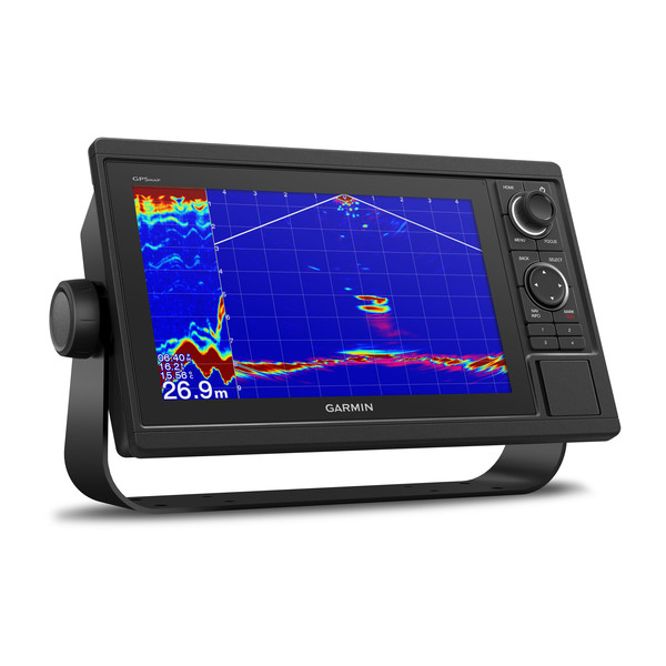
Garmin transducers are fully compatible with the Garmin GPSMAP 1022xsv and will provide you with a live 'view' beneath your boat. We stock the very latest Garmin transducers which can provide you with an image of not only what lies directly below but towards the front or sides of your boat with features such as SideVu, DownVu and RealVu 3D Forward.
To learn more about Garmin transducers please see our Garmin Transducer Buyer's Guide, the page also features an online form, which after completing we will email you a link to compatible transducers that are all fully compatible with your Garmin GPSMAP 1022xsv and the boat in which you will use both nautical devices on.
Pictured below, transom mounted transducer, thru-hull transducer and in-hull transducer.
To find the perfect transducer to partner your GPSMAP 1022xsv and your boat please complete our online transducer form. Alternatively, if you know which transducer your require (we do however recommend that you complete our online form to find the perfect transducer) you can view the comprehensive range of transducers available buy from ActiveGPS. Pictured below, transom mounted transducer, thru-hull transducer and in-hull transducer.
![]()
![]()
‣10-inch multi-touch WXGA screen chartplotter
‣Keypad interface and multifunction control knob
‣Preloaded Garmin worldwide basemap
‣Built-in 10Hx GPS/GLONASS receiver updates your position and heading 10 times per second for fluid display of your movements
‣Waterproof to IPX7
‣Wireless communication via WiFi
‣Digital Switching support
‣Radar compatible
‣Autopilot integration
‣FLIR Thermal Camera and IP Camera support
‣Composite video input
‣VIRB integration compatible
‣FUSION-Link support
‣Quickdraw Contours, Garmin Helm and BlueChart Mobile 2.0 compatible
‣NMEA 0183 and NMEA 2000 compatible
‣Supports optional Garmin BlueChart g3 HD charts for Auto Guidance and other premium navigation features
‣2 year manufacturers guarantee
Flush, Flat and Bail mounting options enable you to mount the GPSMAP 1022 device against most flat surfaces in your boat.
Garmin GPSMAP 1022 marine chartplotter is preloaded with a worldwide basemap. The worldwide basemap is a non-detailed map for general reference.
To add marine charts to the Garmin GPMAP 1022 requires the purchase of a Garmin BlueChart g3 title. With lots of different charts avialable you can find the perfect Garmin Bluechart for the area of water you will be using the Garmin GPSMAP 1022 chartplotter. Three different chart and chart sizes are shown below. The first covers a small area or water (small chart), the second a slightly larger area of water (regular chart), while the third shows the largest chart size (large chart) Garmin produce. View all Garmin GPSMAP 1022 compatible Garmin g3 BlueCharts.
Product Code: GAR1022
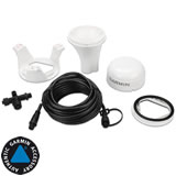
‣GPSMAP 1022 chartplotter
‣Power/data cable
‣NMEA 2000 T-connector
‣NMEA 2000 drop cable (2 m)
‣Bail mount kit with knobs
‣Flush mount kit with gasket
‣Protective cover
‣Trim piece snap covers
‣Documentation
Product Code: GAR1022X
‣GPSMAP 1022 chartplotter
‣Power/data cable
‣NMEA 2000 T-connector
‣NMEA 2000 drop cable (2 m)
‣8-pin transducer to 12-pin sounder adaptor cable
‣Bail mount kit with knobs
‣Flush mount kit with gasket
‣Protective cover
‣Trim piece snap covers
‣Documentation
Looking for accessories and spares for the Garmin GPSMAP 1022? Accessories available to purchase include replacement protective cover, 8-pin power/data cable and bail mount. Pictured below are a few of the other accessories that arecompatible and will enhance the functionality and usability of the Garmin GPSMAP 1022 chartplotter. View all Garmin GPSMAP 1022 accessories.
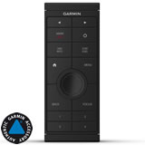
Garmin GPSMAP 1022 GRID 20 Remote Input Device
£269.99
‣Garmin GRID 20 remote input device provides access and control of your entire Garmin marine system.
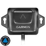
Garmin GPSMAP 1022 GPS 24xd NMEA 2000 Antenna
£269.99
‣Garmin GPS 24xd NMEA 2000 multi band GNSS antenna provides 10Hz position update rates for high-sensitivity tracking.
Garmin GPSMAP 1022 SteadyCast Heading Sensor
£179.99
‣Garmin SteadyCast heading sensor provides fast calibration and premium heading accuracy.
‣Technology: GPS, Chartlotter, Fishfinder
‣Display: 10.1-inch multi-touch WSVGA display (1024 x 600 pixels)
‣Display size: 224mm x 125mm; 257mm diagonal
‣Battery: None
‣Mounting options: Bail mount or flush mount
‣Waypoints/favourites/locations: 5,000
‣Track Log: 50,000 points, 50 saved tracks
‣Routes: 100
‣Basemap: Preloaded with worldwide basemap
‣NMEA input/output: NMEA 2000 and NMEA 0183 compatible
‣Built-in memory: None (cannot load maps to internal memory)
‣SD card slot: Yes, 2 SD Card slots
‣Garmin radar compatible: Yes
‣Garmin sonar compatible: GPSMAP 1022 model: Requires additional purchase of external black box, GPSMAP 1022xsv models: Yes, built-in
‣GSD Black Box Sonar support: Yes
‣GCV Black Box Sonar support: Yes
‣Waterproof: Yes, IPX7
‣Dimensions: Width - 318mm, Height - 185mm, Depth - 69mm
‣Weight: 1.85kg
‣Guarantee: 2-year
‣Garmin GPSMAP 1022 manual
![]() Manual requires Adobe Acrobat Reader
Manual requires Adobe Acrobat Reader
Download a free copy here
This is a sophisticated electronic device. It is important to read, understand, and follow the instructions provided in the user manual (usually available via the 'manual' link above). To ensure optimal performance, you will need internet access and should regularly download and install firmware and software updates as recommended by the manufacturer. Like all GPS devices, it requires a clear view of the sky to connect with satellites, so be aware that certain vehicle glass or enclosures may block or reduce GPS signal reception.
Updates for this device are delivered via the internet. This page provides information on compatibility with current devices such as PCs, laptops, Macs, and smartphones. Under the Consumer Contract Regulations, you have 14 days from receipt of purchase to verify compatibility with your internet-connected device. Please note that if you later replace or upgrade your PC, Mac, or smartphone, neither ActiveGPS nor the manufacturer can guarantee compatibility with the new operating system.
 Why Buy from ActiveGPS?
We are official authorised Garmin Internet Retailers, offering genuine Garmin products, accessories, and maps. All our stock is purchased directly from assigned Garmin UK distributors - we do not source from the grey market and never sell counterfeit products.
When you buy from ActiveGPS.co.uk, you can be confident that you’ll receive full Garmin support and the peace of mind that comes with purchasing authentic, reliable products.
Page last reviewed: 2nd January 2026
ActiveGPS.co.uk
Customer Service
Telephone Number:
01733 777623
Monday to Friday 9:30am to 5:00pm (UK Time)
Follow us on
![]()
![]()
![]()
![]()
![]()

ActiveGPS.co.uk Copyright © Active Alliance Limited 2005-2026 | Company Number - 05200677 | VAT Number - GB 834 2222 57
Text compiled by and copyright Active Alliance Ltd. Plagiarism software in use - do not copy any of our website text, images or videos.