FREE UK delivery when you spend £50 - see more delivery options.

Homepage / Marine / Garmin BlueCharts / BlueChart Europe / g3 Vision Europe Small Charts
Product Code: VEU509S
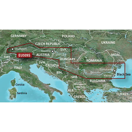

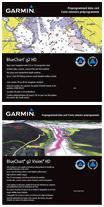
Garmin BlueChart g3 Vision Danube River marine charts on SD/microSD Data Card provides rich, seamless marine charting for compatible Garmin marine chartplotters using integrated Garmin and Navionics data. Additional features include Auto Guidance, MarinerEye view and more (read more below). Map includes coverage of the Danube River in its entirety, Main-Donau Canal to Schwabach, the Neckar River to Stuttgart, Lake Balaton, the Danube Delta and more.
Simply insert the plug-and-play SD/microSD Card into your Garmin, select the chart via your Garmin's on screen menu and you're ready to use the latest available Garmin BlueChart.
Compatibility: Please see 'What is the chart compatible with?' for full list of compatible Garmin handhelds and chartplotters that the Garmin BlueChart g3 Vision Danube River microSD/SD card will work with.
![]()
Special Order item: can take 7 days or more. Garmin BlueChart titles are now all made to order as they require ordering from Garmin. We regret we can no longer dispatch Garmin BlueChart titles sameday when ordered before midday. We apologise for any inconvenience that this may cause.
Garmin BlueChart g3 Vision Danube River microSD/SD card - £214.99
 Garmin BlueChart Deliveries ONLY
Garmin BlueChart titles available to buy from AcrtiveGPS.co.uk are Special Order items and can take 7 days or more to arrive into stock. This is in part to ensure you receive the very latest version of the Garmin marine chart for your device, which is currently v2025. All of our Garmin BlueChart titles are made to order and require ordering from Garmin.
We offer FREE UK delivery on all orders of £50.00 or more. View all delivery options. Delivery options also appear at the basket pages.
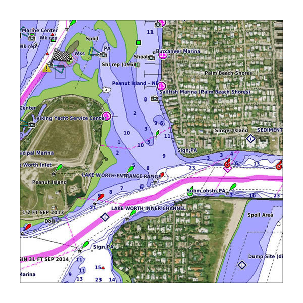
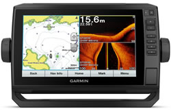
Buy Garmin BlueChart g3 Vision Danube River on microSD/SD card. The marine chart maps provide detailed nautical chart data which enables you to see exactly where your vessel is positioned on BlueChart maps. The BlueChart g3 Vision title includes Auto Guidance technology, this enables you to clearly and easily calculate routes and see a suggested path to follow*. Also displayed are coastal features, anchorages, obstructions, waterways, tidal stations, currents, contour depths and fishing charts.
Plan and organise your route before you get on the water using the optional HomePort software which which allows you to calculate speed, fuel consumption and arrival time as well as distance and heading for your destination. HomePort is also compatible with Google Earth.
Because all BlueCharts are made to order (custom made at time of purchase) they cannot be cancelled once ordered nor returned for refund. Therefore, please ensure that you are definitely ordering the correct chart and that you have checked that is compatible with your device. We cannot accept any cancellation (even if we have not yet despatched it) nor can we accept the return of a BlueChart order as all charts are 'made-to-order'. Please make sure the microSD/SD card you are purchasing is compatible with your Garmin device before placing your Garmin BlueChart order.
*Auto Guidance is for planning purposes only and does not replace safe navigation operations.
‣Detailed coverage of the Danube River in its entirety
‣Main-Donau Canal to Schwabach
‣the Neckar River to Stuttgart
‣the Chiemsee
‣the Neusiedler See
‣Lake Balaton
‣the Sava River
‣the Danube-Black Sea Canal
‣the Danube Delta
‣the Black Sea coast from the Delta to Varna, Bulgaria
 New Chart Guarantee
Buy with confidence from ActiveGPS.co.uk - if a new version of the Garmin Bluechart g3 title you buy is released within 12 months of your purchase from us, you can download the latest version from Garmin for FREE. Find out more about the New Chart Guarantee.
‣Seamless transitions between zoom levels and more continuity across chart boundaries
‣Vector object oriented data
‣Shaded depth contours, coastlines, spot soundings, navaids, port plans, wrecks, obstructions, intertidal zones, restricted areas and IALA symbols
‣1-foot HD contours provide a more accurate depiction of bottom structure for improved fishing charts and navigation in swamps, canals and port plans
‣Port plans
‣Tidal stations for selected countries
‣Aids to navigation with view range and coverage including light sector info
‣Wrecks, restricted areas, anchorages, obstructions
‣Tidal current graphs
‣Standard 2-D direct overhead or 3-D "over the bow" map perspective for easy chart reading and orientation
‣Marina points of interest and slipways
‣Genuine Garmin map product
‣Auto Guidance technology plots best passage on screen
‣Direction of flow for tidal currents
‣High-resolution satellite imagery
‣Overhead aerial photos - ports, harbours, marinas, waterways and coastal roads
‣Displays navigational landmarks and marine landscapes
‣Coastal road coverage for five miles inland (not routable)
‣True 3D-view MarineEye 3D above waterline imagery
‣Fish eye view - 3D view of depths and contours below the water using bathymetric chart data
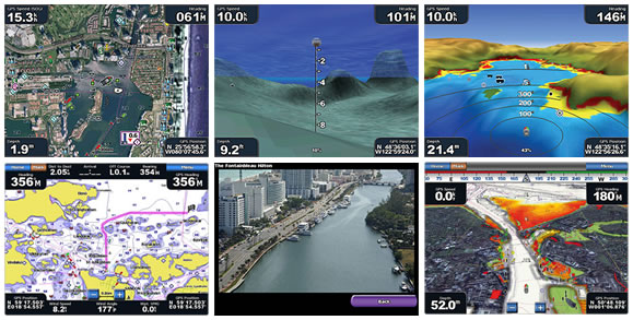
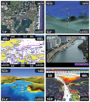
Please note: The images above are screen shots from various Garmin BlueChart g3 Vision charts and NOT necessarily from the BlueChart available to buy from this webpage.
![]()
 The Garmin BlueChart title available to buy on this webpage is a Special Order item, and can take 7 days or more to arrive into stock. This is in part to ensure you receive the very latest version of the Garmin marine chart for your device, which is currently v2025. All of our Garmin BlueChart titles are made to order and require ordering from Garmin. We regret we can no longer dispatch Garmin BlueChart titles sameday when ordered before midday. We apologise for any inconvenience that this may cause. We are however able to produce Garmin Navionics+ and Navionics Vision+ charts sameday, when ordered before 12:00PM (Monday to Friday).
What's more all BlueCharts purchased from ActiveGPS.co.uk come with a FREE new chart guarantee valid for 12 months after purchase, learn more about the new chart guarantee.
IMPORTANT: Because all BlueCharts are made to order (custom made at time of purchase) they cannot be cancelled once ordered nor returned for refund. Therefore, please ensure that you are definitely ordering the correct chart and that you have checked that is compatible with your device.
Please note: Other websites may be selling obsolete versions of this Bluechart, such as V12, V10 or even older.
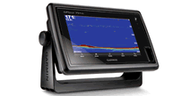
The BlueChart g3 Vision Danube River on SD card is ONLY compatible with the following Garmin products:
 Garmin echoMAP 42dv, echoMAP 43dv, echoMAP 44dv, echoMAP 45dv, echoMAP 50dv, echoMAP 50s, echoMAP 52dv, echoMAP 53cv, echoMAP 53dv, echoMAP 54dv, echoMAP 55dv, echoMAP 70s, echoMAP 70dv, echoMAP 72sv, echoMAP 73dv, echoMAP 73sv, echoMAP 74dv, echoMAP 74sv, echoMAP 75sv, echoMAP 92sv, echoMAP 93sv, echoMAP 94sv, echoMAP 95sv, echoMAP CHIRP 42cv, echoMAP CHIRP 42dv, echoMAP CHIRP 43cv, echoMAP CHIRP 43dv, echoMAP CHIRP 44cv, echoMAP CHIRP 44dv, echoMAP CHIRP 45cv, echoMAP CHIRP 45dv, echoMAP CHIRP 52dv, echoMAP CHIRP 52cv, echoMAP CHIRP 53cv, echoMAP CHIRP 53dv, echoMAP CHIRP 54cv, echoMAP CHIRP 54dv, echoMAP CHIRP 55cv, echoMAP CHIRP 55dv, echoMAP CHIRP 72cv, echoMAP CHIRP 72dv, echoMAP CHIRP 72sv, echoMAP CHIRP 73cv, echoMAP CHIRP 73dv, echoMAP CHIRP 73sv, echoMAP CHIRP 74cv, echoMAP CHIRP 74dv, echoMAP CHIRP 74sv, echoMAP CHIRP 75cv, echoMAP CHIRP 75dv, echoMAP CHIRP 75sv, echoMAP CHIRP 92sv, echoMAP CHIRP 93cv, echoMAP CHIRP 93sv, echoMAP CHIRP 94sv, echoMAP CHIRP 95sv, ECHOMAP Plus 42cv, ECHOMAP Plus 43cv, ECHOMAP Plus 44cv, ECHOMAP Plus 45cv, ECHOMAP Plus 62cv, ECHOMAP Plus 63cv, ECHOMAP Plus 64cv, ECHOMAP Plus 65cv, ECHOMAP Plus 72cv, ECHOMAP Plus 75sv, ECHOMAP Plus 73cv, ECHOMAP Plus 73sv, ECHOMAP Plus 74cv, ECHOMAP Plus 74sv, ECHOMAP Plus 75cv, ECHOMAP Plus 75sv, ECHOMAP Plus 92sv, ECHOMAP Plus 93sv, ECHOMAP Plus 94sv, ECHOMAP Plus 95sv, ECHOMAP UHD 62cv, ECHOMAP UHD 63cv, ECHOMAP UHD 64cv, ECHOMAP UHD 65cv, ECHOMAP UHD 72cv, ECHOMAP UHD 72sv, ECHOMAP UHD 73cv, ECHOMAP UHD 73sv, ECHOMAP UHD 74cv, ECHOMAP UHD 74sv, ECHOMAP UHD 75cv, ECHOMAP UHD 75sv, ECHOMAP UHD 92sv, ECHOMAP UHD 93sv, ECHOMAP UHD 94sv, ECHOMAP UHD 95sv, ECHOMAP UHD2 55cv, ECHOMAP UHD2 65sv, ECHOMAP UHD2 75cv, ECHOMAP UHD2 75sv, ECHOMAP UHD2 95sv, ECHOMAP Ultra 102sv, ECHOMAP Ultra 106sv, ECHOMAP Ultra 122sv, ECHOMAP Ultra 126sv, ECHOMAP Ultra 2 10-inch, ECHOMAP Ultra 2 12-inch, GPSMAP GPSMAP 527/527xs, GPSMAP 557/557xs, GPSMAP 721/721xs, GPSMAP 722/722 Plus, GPSMAP 722xs, GPSMAP 722xs Plus, GPSMAP 723/723xsv, GPSMAP 743/743xsv, GPSMAP 751/751xs, GPSMAP 820/820xs, GPSMAP 922/922 Plus, GPSMAP 922xs/922xs Plus, GPSMAP 923/923xsv, GPSMAP 942/942 Plus, GPSMAP 942sx/942xs Plus, GPSMAP 943/943xsv, GPSMAP 1020/1020xs, GPSMAP 1022/1022xsv, GPSMAP 1040xs, GPSMAP 1042xsv, GPSMAP 1222/1222 Plus, GPSMAP 1222 Touch, GPSMAP 1222xsv, GPSMAP 1222xsv Plus, GPSMAP 1222xsv Touch, GPSMAP 1223/1223xsv, GPSMAP 1242 Plus, GPSMAP 1242 Touch, GPSMAP 1242xsv/1242xsv Plus, GPSMAP 1242xsv Touch, GPSMAP 1243/1243xsv, GPSMAP 7407/7407xsv, GPSMAP 7408/7408xsv, GPSMAP 7410/7410xsv, GPSMA 7412/7412xsv, GPSMAP 7416/7416xsv, GPSMAP 7607/7607xsv, GPSMAP 7608/7608xsv, GPSMAP 7610/7610xsv, GPSMAP 7612/7612xsv, GPSMAP 7616/7616xsv, GPSMAP 8008 MFD, GPSMAP 8012 MFD, GPSMAP 8015 MFD, GPSMAP 8208 MFD, GPSMAP 8212 MFD, GPSMAP 8415 MFD, GPSMAP 8410/8410xsv, GPSMAP 8412/8412xsv, GPSMAP 8416/8416xsv, GPSMAP 8417 MFD, GPSMAP 8422 MFD, GPSMAP 8424 MFD, GPSMAP 8610/8610xsv, GPSMAP 8612/8612xsv, GPSMAP 8616/8616xsv, GPSMAP 8617 MFD, GPSMAP 8622 MFD, GPSMAP 8624 MFD, GPSMAP 8500 Black Box, GPSMAP 8530 Black Box, GPSMAP 8700 Black Box.
 Not sure whether your Garmin marine or handheld system will be compatible with marine blue charts on preprogrammed microSD/SD cards? Simply email us, or use the online form on our contact us page and provide us with the unit's model, part and serial number normally located on the underside of your Garmin product. We'll then reply with the relevant webpage of available bluecharts for you to browse.
We also have a Garmin map Frequently Asked Questions page where you can ask a question and read questions and answers posted by other customers.
Please note: Older Garmin units e.g. GPSMAP 182c required a data card rather than a SD/microSD, but we no longer stock datacard versions of the BlueCharts - these have been discontinued by Garmin.
Garmin Navionics+ and Navionics Vision+ marine charts. Please note: Garmin Navionics marine charts are not compatible with any of the Garmin handheld range and are only generally compatible with Garmin chartplotters which were release since 2020. View the latest Garmin Navionics+ and Navionics Vision+ marine charts to check compatibility with your Garmin chartplotter prior to purchase of your Garmin BlueChart title.
‣SD card adaptor with preprogrammed microSD card inside - Learn how to install Garmin BlueChart maps SD/microSD Card onto your Garmin marine chartplotter/handheld GPS device.
Garmin BlueChart g3 Vision
Garmin part number: 010-C1127-00
Garmin Region code: VEU509S
Please note: Premium features such as quickdraw and 1ft HD fishing contours/1ft shaded depth lines will only display on the latest Garmin chartplotters (there may be other features). Legacy models which don't already offer or include such a feature will not be able to display these features. Please be assured that the new mapping will not remove any features that you already have. To assist customers with older devices Garmin make the latest maps and charts backwards compatible with earlier devices - but data for features introduced for newer devices cannot be processed and displayed by legacy models. Map data cannot upgrade the features of a particular device.
Garmin BlueChart g3 Vision marine charts are available in three different sizes, these are: Small, Regular and Large coverage. Please see the sample charts below, which all include the Thames Estuary:
The larger the chart coverage the more area is covered without the need to change or buy additional charts. We suggest buying the chart(s) that provide the coverage for your sailing, fishing or yachting needs.
Please note: There is no difference in the chart detail between different size charts e.g. a small chart and a regular chart will have exactly the same detail. The ONLY difference is the coverage or area of water that is included within the blue chart. Of course, the larger the chart area, the higher the cost for that chart.
 Why Buy from ActiveGPS?
We are official authorised Garmin Internet Retailers, offering genuine Garmin products, accessories, and maps. All our stock is purchased directly from assigned Garmin UK distributors - we do not source from the grey market and never sell counterfeit products.
When you buy from ActiveGPS.co.uk, you can be confident that you’ll receive full Garmin support and the peace of mind that comes with purchasing authentic, reliable products.
This page was last updated on: 2nd January 2026
ActiveGPS.co.uk
Customer Service
Telephone Number:
01733 777623
Monday to Friday 9:30am to 5:00pm (UK Time)
Follow us on
![]()
![]()
![]()
![]()
![]()

ActiveGPS.co.uk Copyright © Active Alliance Limited 2005-2026 | Company Number - 05200677 | VAT Number - GB 834 2222 57
Text compiled by and copyright Active Alliance Ltd. Plagiarism software in use - do not copy any of our website text, images or videos.