FREE UK delivery when you spend £50 - see more delivery options.

Homepage / GPS / Marine / Chartplotters / Garmin GPSMAP 751
Product Codes: GAR751 and GAR751XS
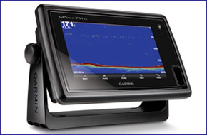
The standalone Garmin GPSMAP 751 chartplotter features a 7-inch display and comes preloaded with BlueChart g2 marine charts of UK and Ireland and worldwide basemap. The 751 features GLONASS GPS which updates your location 10 time each second. There are two models of the GPSMAP 751, these are the 751 and 751xs. The 751xs includes a Sounder that requires a transducer (sold separately) which can define depth contours, show fish passing by and measure depth of objects in the water.
GPSMAP 751 features touchscreen with multitouch. The screen is easy to read in direct, bright sunlight and the processor is fast allowing for quick panning and zooming. The 751 is also WiFi and Bluetooth enabled.
![]()
Garmin GPSMAP 751 and 751xs has been discontinued.
View latest Chartplotters
Although both models have been discontinued, we still sell accessories for both the GPSMAP 751 and GPSMAP 751xs. In addition you can buy the latest marine g3 BlueCharts.
 The Garmin GPSMAP 751 and 751xs are standalone GPS chartplotters. The 751 features a large multitouch 7-inch touchscreen display. It has been designed to be rugged and waterproof to IPX7 standards to be operated in all conditions and situations. The 751 GPS system includes marine charts for UK and Ireland and also comes preloaded with a worldwide basemap. It also features a built-in high-sensitivity GPS receiver. The 751 is also wifi and bluetooth enabled. It is also Fusion Link capable enabling you to connect to other devices with ease.
The GPSMAP 751 makes it easy to plot your route on screen. It is simple to change your course and review information relating to your plotted journey. There are even flexible brightness levels making it daytime readable and it also offers low-light dimming for night time use. Full NMEA 2000 connectivity is offered for engine, fuel, wind, VHF, autopilot and other data monitoring.
The GPSMAP 751 has a 10Hz GPS GLONASS. This updates your location 10 times a second, ideal for when navigating to find a hot fishing spot and mark and quickly navigate to 5,000 waypoints.
Also featuring a built-in radar port the GPSMAP 751 can be used with GMR marine radar systems. The radar benefits from a plug and play installation.
The GPSMAP 751 / 751xs can store 3,000 waypoints, 100 routes, 20,000 points of interest or 50 saved tracks.
The GPSMAP 751xs version includes a sounder. The sounder enables the chartplotter to define the depth of the water, define where fish are and find objects underwater up to 610 metres (2000 feet) below the waters surface. However, for the sounder to function you'll need to separately buy a transducer. There are three types of transducers available. The specific one to buy depends on type of vessel/boat/rib and where or how you'd like to mount the transducer. The three are:
‣Transom Mount - for outboard powered boats and fits to the transom of the boat.
‣In-hull mount - for non-outboard powered boats for only single skin fibre glass boats.
‣Through-hull mount - for non-outboard powered boats. Ideal for wooden, steel boats, etc.
To find the perfect transducer to partner your Garmin GPSMAP 751 and your boat please complete our online transducer form. Alternatively, if you know which transducer your require (we do however recommend that you complete our online form to find the perfect transducer) you can view the comprehensive range of transducers available buy from ActiveGPS. Pictured below, transom mounted transducer, thru-hull transducer and in-hull transducer.
![]()
![]()
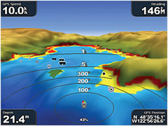
The 751xs model also features a split screen displaying sonar and satellite navigation. The 751xs also features a temperature log and graph with the included water temperature sensor. Furthermore the xs model provides alerts for fish size, shallow and deep water.
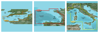
The GPSMAP 751 and 751xs come as standard with Garmin g2 BlueCharts for the waters around the whole of UK and Ireland. Additional BlueCharts e.g. Bay of Biscay and Mediterranean coast of Spain are also available on SD/microSD Card.
The very best charts are BlueChart g3 Vision SD cards. These premium charts include: MarinerEye - keep an eye on 3D information above the waterline, FishEye - provides 3D information below the waterline. Furthermore high-resolution aerial images help you to identify where you should be traveling when you are unfamiliar with the layout of the waterways. There is an Auto Guidance feature that provides a route you can follow which avoids shallow water, buoys and other obstacles.
‣7-inch LED-lit WVGA touchscreen with multitouch
‣Preloaded worldwide basemap
‣Preloaded Garmin BlueChart g2 UK and Ireland
‣WiFi and Bluetooth enabled
‣Fusion Link compatible
‣Streamlined user interface makes it simple to select modes and features
‣Excellent visibility in bright sunlight
‣Fast processor for rapid zooming, panning and updating the image
‣Built-in high-sensitivity GPS receiver
‣GPS GLONASS updates your position 10 time every second
‣NMEA 0183 and NMEA 2000
‣Radar compatibility
‣Waterproof to IPX7
‣Cleaner installation thanks to the newly designed bail mount with cable management capabilities
‣SD card slot allows upgrade to BlueChart g3 cartography
‣1 Year manufacturers guarantee
‣Sounder output: up to 1,000 W (RMS), 8,000 W (PTP), with 1kW transducer
‣Depth: 600metre (with dual frequency, 1kW transducer)
‣UltraSroll: rapid sounder image updating
‣See-Thru technology: shows strong and weak returns simultaneously
‣Sonar recording
‣AutoGain
‣Graphic logging of water temperature
‣Alarm for fish size, shallow and deep water
‣A-scope (real time window)
‣White line
‣2x, 4x and bottom-locked zoom
‣Adjustable keel calibration
‣Split-screen zoom for a close-up view of fish and the bottom
Garmin GPSMAP 751 and 751xs marine chartplotters are preloaded with Garmin BlueChart g2 UK and Ireland.
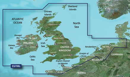
The chart (pictured above) features detailed marine cartography coverage of the British Isles in their entirety, including the Thames Estuary, Caledonian Canal, Outer Hebrides, Shetland and Orkney Islands, Isle of Wight, Isle of Man, and the Irish Sea.
Coverage across the English Channel from Douarnenez, France to Emden, Germany, including the Channel Islands, and the Seine River to Rouen, France Detailed coverage includes Antwerp, Belgium, Rotterdam, Netherlands, Amsterdam, Netherlands, and the Ijsselmeer in full. Read more information about Garmin g3 marine Bluecharts.
In future years you can purchase a marine BlueChart g3 update SD card to update the preloaded UK and Ireland charts on the Garmin GPSMAP 751/751xs.
‣Garmin GPSMAP 751/751xs
‣Preloaded Garmin BlueChart g2 UK and Ireland
‣Tilt/swivel mount
‣Protective front cover
‣Power/data cable
‣Documentationl
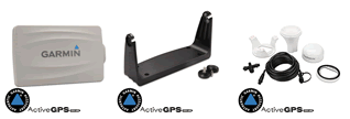
Looking for Garmin GPSMAP 751 or GPSMAP 751xs accessories? Accessories available to purchase include 7-inch protective cover, bail mount with knobs and flush mount kit. If you'd like to add a transducer to your GPSMAP 751xs please see this page.
View all Garmin GPSMAP 751/751xs accessories
Add Garmin BlueChart g3 marine charts to your Garmin GPSMAP 751/751xs, view the different Garmin g3 Bluecharts you can buy from ActiveGPS.
‣Technology: GPS
‣Display: 7-inch WVGA display (800 x 480 pixels)
‣Battery: None
‣Waypoints/favourites/locations: 3,000
‣Routes: 100
‣Track Log: 20,000 points, 50 saved tracks
‣Basemap: Worldwide
‣NMEA input/output: NMEA 0183 compatible and NMEA 2000 certified
‣Built-in memory: None (cannot load maps to internal memory)
‣SD card slot: Yes
‣Garmin radar compatible: Yes
‣Garmin sonar compatible: GPSMAP 750S only
‣Waterproof: Yes, IPX7
‣Dimensions: Width - 224mm, Height - 142mm, Depth - 79mm
‣Weight: 1.1kg
‣Guarantee: 1-year
‣Garmin GPSMAP 751 manual
![]() Manual requires Adobe Acrobat Reader
Manual requires Adobe Acrobat Reader
Download a free copy here
This is a sophisticated electronic device. It is important to read, understand, and follow the instructions provided in the user manual (usually available via the 'manual' link above). To ensure optimal performance, you will need internet access and should regularly download and install firmware and software updates as recommended by the manufacturer. Like all GPS devices, it requires a clear view of the sky to connect with satellites, so be aware that certain vehicle glass or enclosures may block or reduce GPS signal reception.
Updates for this device are delivered via the internet. This page provides information on compatibility with current devices such as PCs, laptops, Macs, and smartphones. Under the Consumer Contract Regulations, you have 14 days from receipt of purchase to verify compatibility with your internet-connected device. Please note that if you later replace or upgrade your PC, Mac, or smartphone, neither ActiveGPS nor the manufacturer can guarantee compatibility with the new operating system.
Why Buy from ActiveGPS?We are official authorised Garmin Internet Retailers, offering genuine Garmin products, accessories, and maps. All our stock is purchased directly from assigned Garmin UK distributors - we do not source from the grey market and never sell counterfeit products.
When you buy from ActiveGPS.co.uk, you can be confident that you’ll receive full Garmin support and the peace of mind that comes with purchasing authentic, reliable products.
Page updated: 2nd January 2026
ActiveGPS.co.uk
Customer Service
Telephone Number:
01733 777623
Monday to Friday 9:30am to 5:00pm (UK Time)
Follow us on
![]()
![]()
![]()
![]()
![]()

ActiveGPS.co.uk Copyright © Active Alliance Limited 2005-2026 | Company Number - 05200677 | VAT Number - GB 834 2222 57
Text compiled by and copyright Active Alliance Ltd. Plagiarism software in use - do not copy any of our website text, images or videos.