FREE UK delivery when you spend £50 - see more delivery options.

Homepage / GPS / Marine / Chartplotters / Garmin GPSMAP 556
Product Code: GAR556
Whether you're looking to enjoy a day out boating or you're after the one that got away, the Garmin GPSMAP 556 offers the brightest, sharpest graphics seen on a 5-inch screen.
Garmin GPSMAP 556 is preloaded with Garmin BlueChart g2 UK and Ireland mapping. On the water for easy marine navigation with no compromise - optional BlueChart g2 Vision cartography provides comprehensive marine charting and 3D views above and below the waterline.
![]()
Garmin GPSMAP 556 has been discontinued.
View latest Chartplotters
Accessories, spares and parts are still available for your GPSMAP 556, as are Garmin GPSMAP 556 g3 marine BlueCharts.
 Garmin GPSMAP 556 is a compact chartplotter that features a high-resolution, super-bright 5-inch VGA colour display along with an improved high-speed digital design for increased map drawing and panning speeds. It’s ready to go with an easy-to-use interface and a built-in, satellite-enhanced basemap preloaded with Garmin BlueChart g2 UK and Ireland marine charts. Garmin GPSMAP 556 also accepts BlueChart g3 cards for added features and functionality such as high-resolution satellite imagery, Mariner’s and Fish Eye views and Auto Guidance technology.
The Garmin GPSMAP 556 comes ready to go with preloaded marine charts for the UK and Ireland. For all other areas, the Garmin GPSMAP 556 has a worldwide basemap with satellite images in place of more traditional maps. The Garmin GPSMAP 556 also comes standard with a high-sensitivity GPS receiver for superior satellite tracking and quicker acquisition times. And with an SD card slot, it’s easy to add additional maps without connecting to a computer.
With the optional BlueChart g3 Vision SD cards, you can add a whole new dimension of exceptional features to your chartplotter.
‣3D mariner's eye view or fish eye view provides you with a 3-dimensional perspective of chart information, both above the waterline and below it.
‣High-resolution satellite images and aerial photographs help you orient yourself in unfamiliar areas.
‣Auto Guidance technology searches through all relevant charts to create a route you can actually follow - one that avoids obstacles, shallow water, buoys and other obstructions.
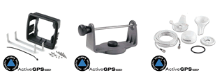
The GPSMAP 556s version includes a sounder. The sounder enables the chartplotter to define the depth of the water, define where fish are and find objects underwater up to 610 metres (2000 feet) below the waters surface. However, for the sounder to function you'll need to separately buy a Garmin Transducer. There are three types of transducers available. The specific one to buy depends on type of vessel/boat/rib and where or how you'd like to mount the transducer. The three are:
‣Transom Mount - for outboard powered boats and fits to the transom of the boat.
‣In-hull mount - for non-outboard powered boats for only single skin fibre glass boats.
‣Through-hull mount - for non-outboard powered boats. Ideal for wooden, steel boats, etc.
To find the perfect transducer to partner your Garmin GPSMAP 556s and your boat please complete our online transducer form. Alternatively, if you know which transducer your require (we do however recommend that you complete our online form to find the perfect transducer) you can view the comprehensive range of transducers available buy from ActiveGPS. Pictured below, transom mounted transducer, thru-hull transducer and in-hull transducer.
![]()
![]()
‣5-inch bright colour VGA display
‣Preloaded worldwide basemap
‣Preloaded Garmin BlueChart g2 UK and Ireland
‣Built-in GPS Antenna
‣Supports AIS and DSC
‣NMEA 2000 compliant
‣Waterproof to IPX7
‣SD card slot allows upgrade to BlueChart g2 Vision cartography
‣1 Year manufacturers guarantee.
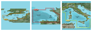
Garmin GPSMAP 556 marine chartplotters are preloaded with Garmin BlueChart g2 UK and Ireland.
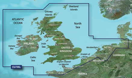
The chart (pictured above) features detailed marine cartography coverage of the British Isles in their entirety, including the Thames Estuary, Caledonian Canal, Outer Hebrides, Shetland and Orkney Islands, Isle of Wight, Isle of Man, and the Irish Sea.
Coverage across the English Channel from Douarnenez, France to Emden, Germany, including the Channel Islands, and the Seine River to Rouen, France Detailed coverage includes Antwerp, Belgium, Rotterdam, Netherlands, Amsterdam, Netherlands, and the Ijsselmeer in full.
In future years you can purchase a marine BlueChart g3 update SD card to update the preloaded UK and Ireland charts on the Garmin GPSMAP 556.
‣Garmin GPSMAP 556
‣Preloaded Garmin BlueChart g2 UK and Ireland
‣Tilt/swivel Mount
‣Protective Front Cover
‣Power/Data Cable
‣Owner's Manual
Looking for Garmin GPSMAP 556 or GPSMAP 556s accessories? Accessories available to purchase include power/data cable and second mounting station. If you'd like to add a transducer to your GPSMAP 556s please see this page.
View all Garmin GPSMAP 556 accessories
Add Garmin BlueChart g3 marine charts to your Garmin GPSMAP 556, view the different Garmin g3 Bluecharts you can buy from ActiveGPS.
Question: I own a GPSmap 556 for use on my boat. How do I update the charts. If there was an internet cable which came with it, I cannot find it! If such a cable exists how do I order it or do I need a new card?
Answer: I can confirm that no such update cable exists.
In order to update your Garmin GPSMAP 556 preloaded charts you will need to buy the BlueChart g3 UK Ireland Update SD card.
If you however you want a different region or to upgrade to the g2 Vision HD version you will need to buy a new chart.
Do you have a question about the Garmin GPSMAP 556? Submit your question via our contact page.
‣Technology: GPS
‣Display: 5-inch VGA display (480 x 640 pixels)
‣Battery: None
‣Waypoints/favourites/locations: 3,000
‣Routes: 100
‣Track Log: 20,000 points, 50 saved tracks
‣Basemap: Worldwide
‣NMEA input/output: NMEA 0183, NMEA 0183 compatible and NMEA 2000 certified
‣Built-in memory: None (cannot load maps to internal memory)
‣SD card slot: Yes
‣Garmin radar compatible: No
‣Garmin sonar compatible: No
‣Waterproof: Yes, IPX7
‣Dimensions: Width - 150mm, Height - 163mm, Depth - 74mm
‣Weight: 0.8kg
‣Guarantee: 1-year
‣Garmin GPSMAP 556 manual
![]() Manual requires Adobe Acrobat Reader
Manual requires Adobe Acrobat Reader
Download a free copy here
This is a sophisticated electronic device. It is important to read, understand, and follow the instructions provided in the user manual (usually available via the 'manual' link above). To ensure optimal performance, you will need internet access and should regularly download and install firmware and software updates as recommended by the manufacturer. Like all GPS devices, it requires a clear view of the sky to connect with satellites, so be aware that certain vehicle glass or enclosures may block or reduce GPS signal reception.
Updates for this device are delivered via the internet. This page provides information on compatibility with current devices such as PCs, laptops, Macs, and smartphones. Under the Consumer Contract Regulations, you have 14 days from receipt of purchase to verify compatibility with your internet-connected device. Please note that if you later replace or upgrade your PC, Mac, or smartphone, neither ActiveGPS nor the manufacturer can guarantee compatibility with the new operating system.
Why Buy from ActiveGPS?We are official authorised Garmin Internet Retailers, offering genuine Garmin products, accessories, and maps. All our stock is purchased directly from assigned Garmin UK distributors - we do not source from the grey market and never sell counterfeit products.
When you buy from ActiveGPS.co.uk, you can be confident that you’ll receive full Garmin support and the peace of mind that comes with purchasing authentic, reliable products.
Page updated: 2nd January 2026
ActiveGPS.co.uk
Customer Service
Telephone Number:
01733 777623
Monday to Friday 9:30am to 5:00pm (UK Time)
Follow us on
![]()
![]()
![]()
![]()
![]()

ActiveGPS.co.uk Copyright © Active Alliance Limited 2005-2026 | Company Number - 05200677 | VAT Number - GB 834 2222 57
Text compiled by and copyright Active Alliance Ltd. Plagiarism software in use - do not copy any of our website text, images or videos.