FREE UK delivery when you spend £50 - see more delivery options.

Home / GPS / Handheld GPS / Garmin Maps / Garmin GB Discoverer Maps
Product Code: GGBNTM13
If you are looking to explore Peddars Way and Norfolk Coastline in England, then the GB Discoverer Peddars Way and Norfolk Coast Path 1:25 000 scale map is the perfect map to use with your compatible Garmin system.
Using map data from the Ordnance Survey OS Explorer map range, these maps provide on-screen rescalable and routable maps, where you'll be able to explore trails, paths, roads and rights of way all with amazing OS 1:25 000 scale map detail. The map comes preloaded on a SD/microSD Card, which then inserts into your Garmin device.
Garmin part number: 010-C0969-00
Compatibility: Compatible with Garmin Dakota 20, eTrex 20/25/30/35, Edge 800/810/1000, Edge Touring/Touring Plus, GPSMAP 62s/62st/62stc, 64/64s/64st, 66s/66st, 78/78s/78sc, 276Cx, Rino 650/650t/655t/750t/755t, Monterra, Colorado series, Montana series, nuvi 500 series, Oregon series. View the full list of compatible Garmin products here or scroll down to 'What is the map compatible with?'.
Please note: This is mapping software only - you need to already own (or purchase) one of the above Garmin devices.
Please note: All Garmin GB Discoverer maps were discontinued by Garmin in April 2018. We still have limited stock of some maps. When they are gone, there will be no more. Buy now to avoid disappointment. Learn more.
IMPORTANT: The Ordnance Survey (OS) map data included with the Garmin GB Discoverer 1:25K Maps of Peddars Way and Norfolk Coast Path microSD/SD card is from December 2008. If you require the latest map OS data, please see: Garmin TOPO Great Britain V3 PRO 1:25K microSD/SD card which was released by Garmin in May 2021.
![]()
Garmin GB Discoverer 1:25K Maps of Peddars Way and Norfolk Coast Path microSD/SD card - £59.99
 Deliveries
We offer UK, Europe and Worldwide deliveries. We despatch orders at 4:30pm on Monday, Tuesday, Wednesday, Thursday and Friday. We need to receive your order on those days by 3:00pm. When possible we may despatch orders received after that time. No orders are despatched on Saturday, Sunday or Bank Holidays in England and Wales.
We offer FREE UK delivery on all orders of £50.00 or more, plus next working day and guaranteed Saturday delivery options. Click here for further info. All options also appear at the basket pages.
Norfolk, where London celebrities seek peace in quaint villages. If you've seen Stephen Fry in 'Kingdom' then you will be familiar with the land and seascapes offered by the Peddars Way trail. From near Cromer head west via Wells and Brancaster to Hunstanton (the only east coast resort where you can watch the sun set over the sea) then head inland towards Thetford Forest. This map is ideal when used with your compatible Garmin device.
Explore and navigate Peddars Way and Norfolk Coast Path with confidence using this genuine Garmin GB Discoverer map which comes supplied on SD card.
Simply insert the microSD/SD card into your compatible Garmin unit and you are ready to walk, hike, ride or hack Peddars Way and Norfolk Coast Path area of Scotland with an OS map at a scale of 1:25K - as recommended by Ordnance Survey for outdoor activities.
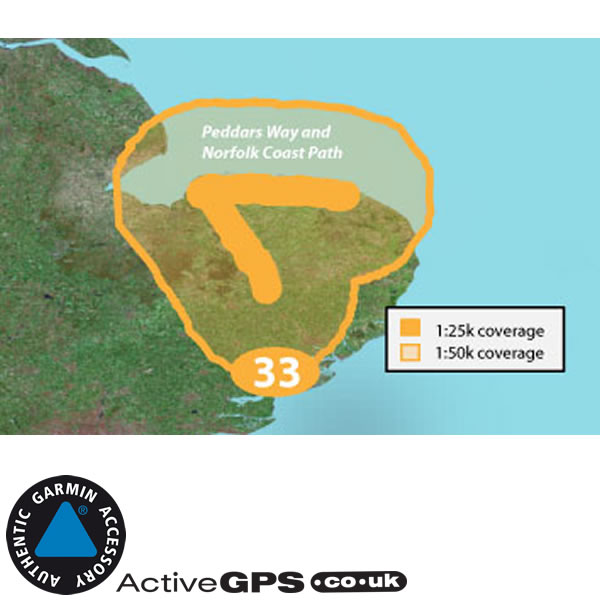
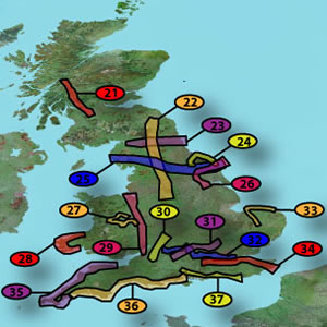
Peddars Way and Norfolk Coast Path GB Discoverer map covers the shaded area number 33 on the UK map below.
 When inserted into a compatible Garmin device the GB Discoverer Peddars Way and Norfolk Coast Path maps provide Ordnance Survey (OS) maps at a scale of 1:25 000 for the entire National Trail area. Plus a 1:50 000 scale map for the same area and slighly beyond that area. The map data is the same as the scale found in the OS Explorer Map series (same as the OS orange cover paper maps ). Rather than having folding paper maps to deal with, OS maps are all on your Garmin screen and in the palm of your hand.
As an added bonus this map also includes OS mapping for ALL of Great Britain - but at a lesser scale of 1:250 000 and 1:1000 000. This OS mapping is viewable down to the 0.8mile resolution of a Garmin handheld (e.g. in a Garmin Colorado and a Garmin Oregon). Any closer than 0.8mile, e.g. 0.5miles, and the mapping reverts to the (also included) NAVTEQ road mapping - still very useful, with road names - AND don't forget that this is for ALL of Great Britain, not just the specific National Park or Trail which this map covers at 1:25K.
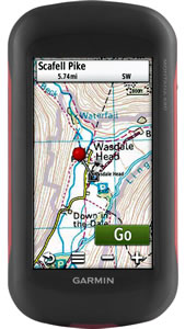
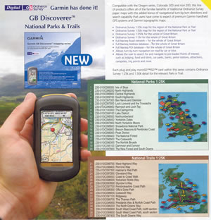
Pictured left: The Garmin Montana 680 with on-screen OS Explorer 1:25 000 maps.
Please note: Display may differ from unit to unit. Garmin GPS device sold separately.
IMPORTANT: The Ordnance Survey (OS) map data included with the Garmin GB Discoverer 1:25K Maps of Peddars Way and Norfolk Coast Path microSD/SD card is from December 2008. If you require the latest map OS data, please see: Garmin TOPO Great Britain V3 PRO 1:25K microSD/SD card which was released by Garmin in May 2021.
‣1:25 000 Ordnance Survey Explorer maps of Peddars Way and Norfolk Coast Path
‣1:50 000 Ordnance Survey Landranger maps for the preloaded region, in addtion to the 1:25K map
‣1:250 000 Ordnance Survey for the whole of Great Britain
‣1:1000 000 Ordnance Survey for the whole of Great Britain
‣NAVTEQ street-level road maps for the whole of Great Britain
‣Includes terrain contours, topo elevations, summits, paths and routable roads
‣Designed for walking, hiking, trekking, hacking, cycling and includes turn-by-turn directions (if applicable to your device)
‣Full topographic relief Ordnance Survey map data
‣Points of interest including campsites, hotels, B&Bs, restaurants, cafe, leisure attractions and geographical reference points
‣Map preloaded on microSD card within an SD card adaptor - compatible with units below
‣December 2008 map data
‣Genuine Garmin map
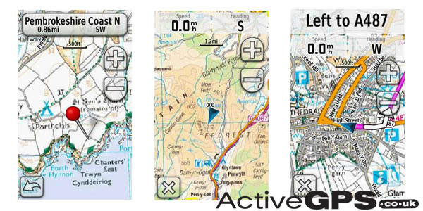
Please note: The images above are screen shots from various GB Discoverer maps and NOT necessarily from the Peddars Way and Norfolk Coast Path map.
The Peddars Way and Norfolk Coast Path 1:25K map on SD card is compatible with Garmin handheld models manufactured since 2008, and must include an SD or microSD card slot. The models the GB Discoverer map is compatible with are as follows:
Garmin Astro 320, 430, Colorado 300, 400c, 400i, 400t, Dakota 20, Edge 800, 810, 1030, Explore 820, Touring, Touring Plus, epix Pro (Gen 2), eTrex 20, 20x, 22x, 30, 30x, 32x, Touch 25, Touch 35, GPSMAP 62s, 62sc, 62st, 62stc, 64, 64s, 64sc, 64st, 64x, 64sx, 65, 65s, 66i, 66s, 66sr, 66st, 67, 67i, 78, 78s, 78sc, 79s, 79sc, 86i, 86s, 276Cx, Montana 600, 610, 650, 650t, 680, 680t, 700, 700i, 710, 710i, 750i, 760i, Monterra, nuvi 500,510, 550, Oregon 450, 450t, 550, 550t, 600, 600t, 650, 650t, 700, 750, 750t, Rino 650, 650t, 655t, 750t, 755t.
Mapping for Peddars Way and Norfolk Coast Path comes supplied on a microSD inside a larger SD card adaptor. To install insert either the full size or microSD card (depending on your model) into a compatible Garmin GPS device (see compatibility list above).
Please note: When using the purchased map, the SD card needs to remain in your Garmin device at all times so the map can be read. The map card cannot be copied to either your Garmin unit or external hard drive. However the map SD card can be used in multiple compatible Garmin devices, but only one at a time. For further help with installing and loading Garmin SD/microSD Cards click here.
The Peddars Way and Norfolk Coast Path Garmin GB Discoverer 1:25K map (010-C0969-00) covers just a small area of Great Britain. However, you might like to consider an alternative Garmin GB Discoverer Ordnance Survey (OS) map covering a larger area is listed below.
‣1:50K All of Great Britain - provides OS detail at 1:50K scale only for all of Great Britain.
A number of 1:25K OS Explorer maps covering Great Britain's National Parks may also be available to buy, these are pictured below.
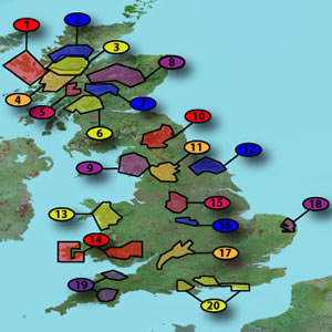
In addtion to the National Parks, there are also other maps at a scale of 1:25K which cover Great Britain's National Trails, as pictured below.
In total there were 42 maps in the complete GB Discoverer series (although some are now no longer available). To view them all click here.
Click on the above image to view high resolution version and read about the Discoverer maps along with the original list of National Parks and National Trails.
 Why Buy from ActiveGPS?
We are official authorised Garmin Internet Retailers, offering genuine Garmin products, accessories, and maps. All our stock is purchased directly from assigned Garmin UK distributors - we do not source from the grey market and never sell counterfeit products.
When you buy from ActiveGPS.co.uk, you can be confident that you’ll receive full Garmin support and the peace of mind that comes with purchasing authentic, reliable products.
This page was last updated on: 2nd January 2026
ActiveGPS.co.uk
Customer Service
Telephone Number:
01733 777623
Monday to Friday 9:30am to 5:00pm (UK Time)
Follow us on
![]()
![]()
![]()
![]()
![]()

ActiveGPS.co.uk Copyright © Active Alliance Limited 2005-2026 | Company Number - 05200677 | VAT Number - GB 834 2222 57
Text compiled by and copyright Active Alliance Ltd. Plagiarism software in use - do not copy any of our website text, images or videos.