FREE UK delivery when you spend £50 - see more delivery options.
Homepage / Marine / Garmin BlueChart / Garmin BlueChart g2 versus BlueChart g2 HD
In 2016 Garmin released a brand new version of their popular Garmin marine cartography series named BlueChart g2 HD and BlueChart g2 Vision HD. What's the difference between the non HD versions and these new HD versions?
The new BlueChart g2 HD and g2 Vision HD versions both include:
‣1-foot HD contours
‣Shallow water shading
‣Shaded depth contours
‣Fishing contours
Read more about the new BlueChart g2 Vision HD charts
As with previous Garmin BlueCharts there are TWO different versions in the BlueChart series. These are Garmin BlueChart g2 HD and BlueChart g2 Vision HD with charts being supplied on SD/microSD Card.
As a general rule of thumb BlueChart g2 HD charts are designed for use with Garmin handheld devices such as the Garmin Montana 680t, while the more advanced BlueChart g2 Vision HD charts are designed for use with Garmin chartplotters such as the Garmin echoMAP 75sv.
To learn more about either version please see BlueChart g2 HD charts and BlueChart g2 Vision HD charts.
The comparison table below compares the features of the BlueChart g2 HD and g2 Vision HD versions.
 |
 |
|
Features |
||
Vector object orientated data |
Yes |
Yes |
Shaded depth contours and inter-tidal zones with spot soundings |
Yes |
Yes |
Port plans |
Yes |
Yes |
Tidal stations for selected countries |
Yes |
Yes |
Aids to navigation including ranges and light sectors information |
Yes |
Yes |
Wrecks, restricted areas, anchorages, obstructions |
Yes |
Yes |
Tidal current graphs |
Yes |
Yes |
2D or 3D map perspective view |
Yes |
Yes |
Marina points of interest and slipways |
Yes |
Yes |
1-foot HD Fishing charts providing detailed contours |
Yes |
Yes |
Point-to-point Auto Guidance technology to suggest best passages |
No |
Yes |
Tidal current flow overlay |
No |
Yes |
Aerial photos of ports, marinas, bridges & navigational landmarks |
No |
Yes |
Detailed coastal roads up to five miles inland (non-routable) |
No |
Yes |
POIs such as restaurants, lodging, entertainment and more |
No |
Yes |
Realistic "view from space" high-resolution satellite imagery |
No |
Yes |
True 3D-view "MarinerEye 3-D" above-waterline imagery |
No |
Yes |
FishEye 3-D view below-waterline imagery |
No |
Yes |
The new Garmin BlueChart g2 HD charts now includes the following features:
‣1-foot HD contours
‣Shallow water shading
‣Shaded depth contours
‣Fishing contours
‣Seamless transitions between zoom levels and more continuity across chart boundaries
‣Vector object oriented data
‣Shaded depth contours, coastlines, spot soundings, navaids, port plans, wrecks, obstructions, intertidal zones, restricted areas and IALA symbols
‣Port plans
‣Tidal stations for selected countries
‣Aids to navigation with view range and coverage including light sector info
‣Wrecks, restricted areas, anchorages, obstructions
‣Tidal current graphs
‣Standard 2-D direct overhead or 3-D "over the bow" map perspective for easy chart reading and orientation
‣Marina points of interest and slipways
With vastly superior contour coverage compared to the old, now discontinued non HD version of the BlueChart g2 charts, the new g2 HD charts provide far more accurate depiction of the seabed beneath your boat, dinghy, etc.
The new g2 HD charts also provide seamless chart presentation with features such as shallow water shading, shaded depth contours and fishing contours. Providing fishing contours for example, (as pictured below) enables you to have a clearer view of the ocean floor to catch more fish.
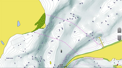
Garmin BlueChart g2 HD - Fishing Contour Chart
Buy a Garmin BlueChart g2 HD chart from ActiveGPS
 Garmin BlueChart g2 Vision HD chart
As well as the g2 HD content and features listed above the new Garmin BlueChart g2 Vision HD charts also include the following features:
‣Garmin 3.0 Auto Guidance
‣Seamless chart presentation
‣Vector object oriented data
‣Shaded depth contours and inter-tidal zones with spot soundings
‣Port plans
‣Tidal stations for selected countries
‣Aids to navigation with view range and coverage including light sector info
‣Wrecks, restricted areas, anchorages, obstructions
‣Tidal current graphs
‣2-D or 3-D map perspective view
‣Full bathymetric fishing charts providing detailed contours
‣Aerial photos of ports, marinas, bridges and navigational landmarks
‣Detailed coastal roads up to 5 miles inland (non-routable)
‣Points of interest such as restaurants, lodging, entertainment and more
‣Aerial photos of ports, marinas, bridges and navigational landmarks and realistic "view from space" high-resolution satellite imagery
‣3-D FishEye and 3-D MarinerEye view
‣Tidal current flow overlay
Garmin BlueChart g2 Vision HD charts feature Garmin Auto Guidance 3.0 technology. Simply enter your boat's dimensions into your Garmin chartplotter and the software will automatically create a visual path for you to navigate.
What's more your Garmin chartplotter, with the new g2 Vision HD chart, will seek to avoid low bridges, shallow water and other charted obstructions. With version 3.0, Auto Guidance you can be guided in and out of more places more effectively, including when entering and exiting marinas.
Buy a Garmin BlueChart g2 Vision HD chart from ActiveGPS.
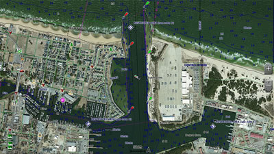
Garmin BlueChart g2 Vision HD - High-Resolution Satellite Imagery
 We are official Authorised Internet Retailers for Garmin. We sell genuine Garmin products, accessories and maps. We purchase from assigned Garmin UK distributors. We do not buy on the grey market and we do not sell counterfeit products. You can rest assured that by purchasing from ActiveGPS you will receive the full support of Garmin.
This page was last updated on: 23rd July 2024
ActiveGPS.co.uk
Customer Service
Telephone Number:
01733 777623
Monday to Friday 9:30am to 5:00pm (UK Time)
Follow us on
![]()
![]()
![]()
![]()
![]()

ActiveGPS.co.uk Copyright © Active Alliance Limited 2005-2024 | Company Number - 05200677 | VAT Number - GB 834 2222 57
Text compiled by and copyright Active Alliance Ltd. Plagiarism software in use - do not copy any of our website text, images or videos.