FREE UK delivery when you spend £50 - see more delivery options.

Homepage / GPS / Handheld GPS / Magellan Accessories / Magellan Maps
Product Code: MTOM4
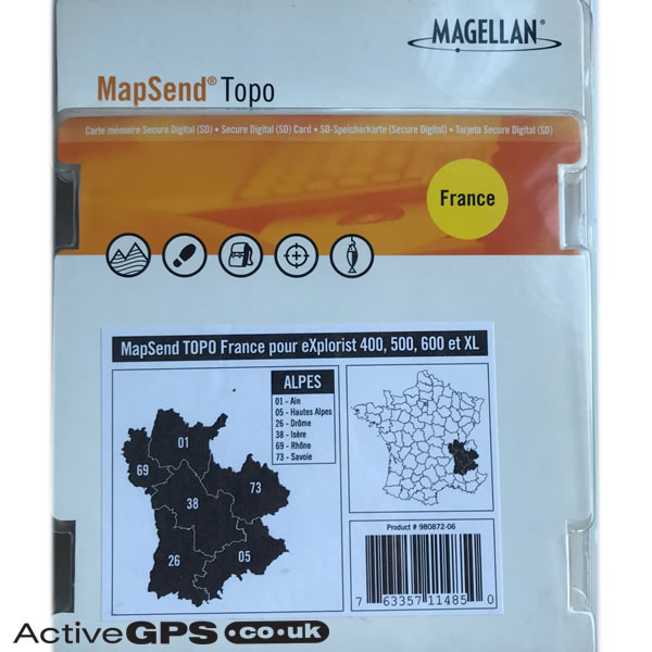
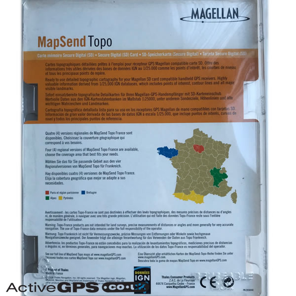
Magellan TOPO maps of the French Alps features highly valuable information derived from 1:25,000 IGN databases, which includes points of interest, contour lines and all major visible landmarks.
The map is supplied on pre-programmed SD card and includes IGN TOPO coverage for the following French regions: 01 - Ain, 05 - Hautes Alpes, 26 - Drome, 38 - Isere, 69 - Rhone and 73 - Savoie.
Map data: Copyright 2006.
Magellan part number: 980872-06
Compatibility: Compatible with Magellan eXplorist 400, eXplorist 500, eXplorist 600, eXplorist XL.
![]()
Magellan MapSend TOPO maps French Alps SD card - £29.99
 Deliveries
We offer UK, Europe and Worldwide deliveries. We despatch orders at 4:30pm on Monday, Tuesday, Wednesday, Thursday and Friday. We need to receive your order on those days by 3:00pm. When possible we may despatch orders received after that time. No orders are despatched on Saturday, Sunday or Bank Holidays in England and Wales.
We offer FREE UK delivery on all orders of £50.00 or more, plus next working day and guaranteed Saturday delivery options. Click here for further info. All options also appear at the basket pages.
TOPO maps of the French Alps features highly valuable information derived from 1:25,000 IGN databases, which includes points of interest, contour lines and all major visible landmarks. The map includes IGN TOPO coverage for the following French regions: 01 - Ain, 05 - Hautes Alpes, 26 - Drome, 38 - Isere, 69 - Rhone and 73 - Savoie.
Ready to use detailed French Alps topographic cartography on pre-programmed SD card for use with the Magellan eXplorist 400, Magellan eXplorist 500, Magellan eXplorist 600 and Magellan eXplorist XL handheld GPS receivers.
‣Includes 1:25K TOPO maps for Alps in France
‣Designed for walking, trekking, cycling and more
‣Features topographical map data provided by IGN
‣Includes footpaths (Private/Public), National Park boundaries, roads, rivers, lakes, campsites
‣Includes other Points Of Interest (POI)
‣Map data: Copyright 2006
‣Genuine Magellan Accessory
‣Preloaded SD card containing topo maps for Topo France - Alps
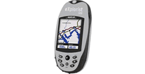 What are the Magellan MapSend TOPO French Alps maps compatible with?
The Magellan topographical maps are compatible with the following Magellan eXplorist handhelds:
Magellan eXplorist 400, eXplorist 500, eXplorist 600, eXplorist XL.
Page updated: 2nd January 2026
ActiveGPS.co.uk
Customer Service
Telephone Number:
01733 777623
Monday to Friday 9:30am to 5:00pm (UK Time)
Follow us on
![]()
![]()
![]()
![]()
![]()

ActiveGPS.co.uk Copyright © Active Alliance Limited 2005-2026 | Company Number - 05200677 | VAT Number - GB 834 2222 57
Text compiled by and copyright Active Alliance Ltd. Plagiarism software in use - do not copy any of our website text, images or videos.