FREE UK delivery when you spend £50 - see more delivery options.

Homepage / GPS / Handheld GPS / Garmin GPSMAP 64s
Product Code: GAR64S
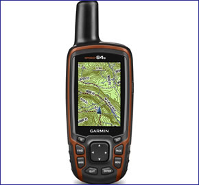
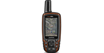
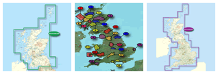
The Garmin GPSMAP 64s is a handheld GPS device which is ideal for walking, hiking, biking and more. The GPSMAP 64s has a 2.6-inch colour screen and has a GPS and GLONASS receiver for superior satellite connectivity. It comes preloaded with UK and Ireland topographical mapping and a worldwide shaded relief basemap. With this GPSMAP 64s you also get an altimeter and 3 axis compass.
This GPSMAP 64s also connects wirelessly to your smartphone and via ANT+ which enables Live Track and Smart notification. You can power the GPSMAP device using either a power pack or AA batteries for a battery life of up to 16 hours.
You can add additional mapping to this GPSMAP 64s for recreational use, driving, use on water and more. It is also perfect for paperless geocaching as it will record location, terrain, difficulty, hints and descriptions.
![]()
Garmin GPSMAP 64s has been discontinued.
View latest handheld GPS.
Buy Garmin GPSMAP 64s accessories
 Deliveries
We offer UK, Europe and Worldwide deliveries. We despatch orders at 4:30pm on Monday, Tuesday, Wednesday, Thursday and Friday. We need to receive your order on those days by 3:00pm. When possible we may despatch orders received after that time. No orders are despatched on Saturday, Sunday or Bank Holidays in England and Wales.
We offer FREE UK delivery on all orders of £50.00 or more, plus next working day and guaranteed Saturday delivery options. Click here for further info. All options also appear at the basket pages.
 Garmin GPSMAP 64s is a slim, lightweight handheld GPS device built to navigate you along walks, over rough terrain, on your bike ride and more. It has a 2.6-inch sunlight readable colour screen and has a GPS and GLONASS receiver with a quad helix antenna for quick acquisition of satellites and it will maintain its GPS fix. The GPSMAP 64 will even maintain its GPS connection in thick woods, deep valleys and when amongst tall buildings.
The GPSMAP 64s is part of the Garmin GPSMAP 64-series and includes the following premium features:
‣Preloaded topographical maps for UK and Ireland light version
‣Electronic compass and barometric altimeter - the 's' in 64s
‣Internal 3.5GB memory
If you would like to buy a handheld GPS device with Full European Topographical mapping then we recommend that you buy the GPSMAP 64st instead.
It is preloaded with topographical maps of UK and Ireland and also a worldwide base map with shaded relief. You also get turn-by-turn navigation along trails and paths whereby routes are calculated tailored to the leisure or sport activity. The GPSMAP 64s is also equipped with an altimeter and 3 axis compass.
It has been built to be used in many conditions including when wearing gloves, cold and wet environments, etc.. It has a button interface for quick, easy control and has been built to be rugged and waterproof to IPX7 standards. The GPSMAP 64s can be powered with either the battery pack or AA batteries and has a battery life of 16 hours.
The GPSMAP 64s connects wirelessly to your smartphone and via ANT+ which enables Live Track and Smart notification.
 There is also a microSD card slot that is used to add further mapping capabilities to the device. There is also 3.5GB of internal memory to store information. Mapping you may want to add to the GPSMAP 64 include Topographical maps for navigating countryside, hills and mountains and GB Discoverer ordnance survey 1:25k or 1:50k are for walking, hiking and biking. Furthermore marine maps are perfect for use on the water and City Navigator maps are available for navigating you on road. You can also get Garmin Custom Maps which convert both paper and electronic maps for use on your device. It is also preloaded with BirdsEye Satellite Imagery with a 1 year free trial subscription.
The GPSMAP 64s is perfect for geocaching and many other activities including walking, hiking and biking adventures as it allows you to record information about geocaches such as location, terrain, difficulty, hints, descriptions. It thus supports paperless geocaching and correspondingly can store 250,000 preloaded caches, hints and descriptions. You can also store waypoints, tracks and routes off the beaten track. There is also a TrackBack feature that enables you to navigate back where you came from.
The GPSMAP 64s also offers further functionality. You can display and enter coordinates in British Grid format like the grid used on Ordnance Survey maps. Topographical maps can be viewed in 2D or 3D on a computer and it will show contour lines and elevation profiles. What's more BaseCamp software enables you to organise maps, waypoints, routes and tracks on your computer before you set off on your journey. Then you can also share with friends, family and fellow explorers your routes and waypoints using Garmin Adventures.
Do you have a question about the Garmin GPSMAP 64s or other handheld GPS related question that's not been answered on this webpage? Please see our handheld and Outdoor GPS FAQs page for questions from other customers. Plus if the answer to your question isn't featured, use the online form to ask us for the answer. Alternatively please telephone 01733 777623 Monday to Friday (9:30am-5:00pm) to speak to one of our sales team. For further information online please see the Garmin GPSMAP comparison table.
‣Slim, lightweight
‣Topographical UK and Ireland mapping (light version)
‣Bright 2.6-inch sunlight readable colour display (160 x 240 pixels)
‣Worldwide built-in basemap with shaded relief
‣High-sensitivity, GLONASS-enabled GPS receiver
‣Electronic compass and barometric altimeter
‣Rugged, waterproof (IEC 60529 IPX7)
‣3.5GB internal memory
‣Supports paperless geocaching; store waypoints, routes, tracks, hints and descriptions
‣TrackBack feature
‣Up to 16 hours of battery life, battery type: 2 AA batteries (not included) or NiMH
‣USB and NMEA 0183 compatible
‣2 year guarantee
Garmin GPSMAP 64s is preloaded with a worldwide basemap with shaded relief and topographic maps for Europe. Please note: Additional maps can be loaded to the GPSMAP 64s. The GPSMAP 64s features a SD/microSD Card slot, an easy way to add new maps and mapping updates.
‣GPSMAP 64s
‣Preloaded "TOPO UK & Ireland Light" map
‣1-year BirdsEye Satellite Imagery subscription
‣Carabiner clip
‣USB cable
‣Documentation
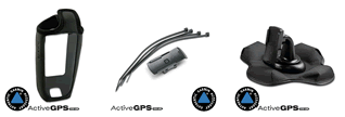
Looking for accessories to use with the Garmin GPSMAP 64s handheld device? We sell a vast selection of genuine parts and spares including GPSMAP 64s slip case, retractable lanyard, carabiner clip and bike/handlebar mount.
View all Garmin GPSMAP 64s accessories
Garmin GPSMAP 64s is preloaded with a Worldwide basemap with shaded relief. However, a number of other maps supplied on SD/microSD Card are also compatible including street-level road maps - perfect for cycling of using your GPSMAP 64s in a car, 1:50k and 1:25k Ordnance Survey maps - ideal for hiking and walking the countryside of Great Britain and marine BlueCharts - ideal if you want to navigate the waters around the UK, Europe or further afield.
View all Garmin GPSMAP 64s maps
Question: I have a Garmin GPSmap 64s and am going walking on Madeira any SD cards available?
Answer: The only Garmin map we sell that is compatible with the Garmin GPSMAP 64s which features Madeira is the Garmin City Navigator NT Maps of Spain and Portugal SD card.
Do you have a question about the Garmin GPSMAP 64s? Submit your question via our contact page.
‣Technology: GPS
‣Display: transflective, 65-K colour TFT (160 x 240 pixels)
‣Touchscreen: No
‣Battery: 2 AA batteries (not included) or (optional) NiMH battery pack
‣Waypoints/favourites/locations: 5,000
‣Routes: 200
‣Track Log: 10,000 points, 200 saved tracks
‣Basemap: Worldwide
‣Built-in memory: 8GB
‣Accepts data cards: Yes
‣Waterproof: Yes, IPX7
‣Dimensions: Width - 61mm, Height - 160mm, Depth - 36mm
‣Weight: 260.1grams
‣Guarantee: 2-year
‣Garmin GPSMAP 64s manual
![]() Manual requires Adobe Acrobat Reader
Manual requires Adobe Acrobat Reader
Download a free copy here
This is a sophisticated electronic device. It is important to read, understand, and follow the instructions provided in the user manual (usually available via the 'manual' link above). To ensure optimal performance, you will need internet access and should regularly download and install firmware and software updates as recommended by the manufacturer. Like all GPS devices, it requires a clear view of the sky to connect with satellites, so be aware that certain vehicle glass or enclosures may block or reduce GPS signal reception.
Updates for this device are delivered via the internet. This page provides information on compatibility with current devices such as PCs, laptops, Macs, and smartphones. Under the Consumer Contract Regulations, you have 14 days from receipt of purchase to verify compatibility with your internet-connected device. Please note that if you later replace or upgrade your PC, Mac, or smartphone, neither ActiveGPS nor the manufacturer can guarantee compatibility with the new operating system.
Why Buy from ActiveGPS?We are official authorised Garmin Internet Retailers, offering genuine Garmin products, accessories, and maps. All our stock is purchased directly from assigned Garmin UK distributors - we do not source from the grey market and never sell counterfeit products.
When you buy from ActiveGPS.co.uk, you can be confident that you’ll receive full Garmin support and the peace of mind that comes with purchasing authentic, reliable products.
Page updated: 2nd January 2026
ActiveGPS.co.uk
Customer Service
Telephone Number:
01733 777623
Monday to Friday 9:30am to 5:00pm (UK Time)
Follow us on
![]()
![]()
![]()
![]()
![]()

ActiveGPS.co.uk Copyright © Active Alliance Limited 2005-2026 | Company Number - 05200677 | VAT Number - GB 834 2222 57
Text compiled by and copyright Active Alliance Ltd. Plagiarism software in use - do not copy any of our website text, images or videos.